 BGS Data Catalogue
MS Excel
Type of resources
Topics
Keywords
Contact for the resource
Provided by
Years
Formats
Representation types
Update frequencies
Scale
-
The dataset is a subset of the BGS borehole material database, created on August 1st 2015 covering only the Bowland-Hodder geological unit (as defined and mapped by Andrews et al., 2013). It shows all boreholes (name, location and registration details) for which BGS hold borehole material (drillcore, cuttings, samples and their depth ranges). This data will add value to existing NERC (Natural Environment Research Council) data by allowing a simple route for users to identify borehole material from the Bowland-Hodder interval.
-
This file documents the strontium isotope data, and the manner in which it has been processed, to supply the reference data for isotope domains of the Biosphere Isotope Domains GB (V1) map. It includes a summary of the analytical methods used to determine the isotope ratios though time.
-
This file documents the sulphur isotope data, and the manner in which it has been processed, to supply the reference data for isotope domains of the Isotope biosphere domains GB (V1) map. It includes a summary of the analytical methods used to determine the isotope ratios though time.
-
The borehole is located at the UK Centre for Ecology and Hydrology (UKCEH), screened between 2 and 4.5 m in the Thames gravels, and drilled to a total depth of 4.8m. It is located on an actively managed grass verge with popular and sycamore trees within 10 m. The stilling well is positioned 420 m west of the borehole in the River Thames. Both stage and groundwater level were monitored at 1-minutre frequency to investigate hydrological fractal scaling of high frequency data between 2012 and 2016. An automatic weather station is present between the borehole and stilling well and the data are available separately from UKCEH (stetur@ceh.ac.uk). Further site description is provided in: Habib, A. et al. 2017. Journal of Hydrology, 549, 715-730. Habib, A. et al. 2022. Hydrological Sciences Journal
-

Concentrations of total organic carbon (TOC), total petroleum hydrocarbons, polycyclic aromatic hydrocarbons (PAHs) and polychlorinated biphenyls (PCBs) were determined in 84 near-surface soils (5-20 cm depth) taken from a 255 km2 area of Glasgow in the Clyde Basin, UK, during July 2011. Total petroleum hydrocarbon ranged from 79-2,505 mg kg-1 (mean 388 mg kg-1; median 272 mg kg-1) of which the aromatic fraction was 13-74 % (mean 44 %, median 43 %) and saturates were 28-87 % (mean 56 %, median 57 %). Σ16 PAH varied from 2-653 mg kg-1 (mean 32.4 mg kg-1; median 12.5mg kg-1) and Σ31 PAH range was 2.47-852 mg kg-1 (mean 45.4 mg kg-1; median 19.0 mg kg-1). PCB tri-hepta range was 2.2-1052 mg kg-1 (mean 32.4 mg kg-1; median 12.7 mg kg-1) and the ΣPCB7 was 0.3-344 mg kg-1 (mean 9.8 mg kg-1; median 2.7 mg kg-1). This data is associated with the published research paper https://doi.org/10.1017/S1755691018000324 Kim, A.W., Vane, C.H., Moss-Hayes, V. Berriro, D.B., Fordyce, F., Everrett, P. Nathanail, P.C. 2018. Polycyclic aromatic hydrocarbons (PAH) and polychlorinated biphenyls (PCB) in urban soils of Glasgow, UK. Earth and Environmental Science Transactions of the Royal Society of Edinburgh 108, 2-3, 231-248.
-

Surface waters and shallow groundwater samples were collected by completely filling 30 mL polyethylene bottles, which were then sealed with electrical tape to minimise the risk of evaporative loss. Rainwater samples were integrated samples of total monthly rainfall collected in a specially-adapted rainfall collector following IAEA protocols (IAEA http://www-naweb.iaea.org/napc/ih/documents/userupdate/sampling.pdf [accessed 22 June 2012). Stable isotopes of oxygen and hydrogen were determined simultaneously using a 'Picarro' WS-CRDS system at the University of Liverpool or the University of Cambridge. Jamaica, Parish of St Elizabeth. Wallywash Great Pond (lat: 17.9716°; long: -77.8068°) (lake water and groundwater samples) and Pon de Rock Guest House (lat: 17.9156°; long: -77.7973°) (rainwater samples). Refer to accompanying map for the precise location of the lake water sampling sites
-

The datasets consist of a spreadsheets containing sporomorph and biomarker data for 145 samples from Eocene sediments recovered by Integrated Ocean Drilling Programme Expedition 318. We studied palynology (pollen and dinocysts) and palaeothermometry based on Glycerol Dialkyal Glycerol Tetraethers (GDGTs) to a sedimentary record from the Wilkes Land margin, East Antarctica, recovered by the Integrated Ocean Drilling Program (IODP Expedition 318 Site U1356). These data sets provide the framework for a terrestrial climate reconstruction for the early Eocene of Antarctica. Further details of the data and their interpretation may be found in Pross et al. (2012), doi:10.1038/nature11300 and Bijl et al. (2013), PNAS, doi/10.1073/pnas.1220872110 The associated NERC grant is NE/I00646X/1 and NE/I00646X/2.
-
This data compilation contains uranium isotopes (234U/235U/238U) and concentration data on a suite of terrestrial and extra-terrestrial samples for understanding the uranium isotope cycling on Earth. Sample list includes meteorites (ordinary chondrites, eucrites), mantle-derived basalts (Ocean Island Basalts, Mid-Ocean Ridge Basalts), arc volcanics, altered oceanic crust (ODP 801), volcanici-clastic sediments, seawater, fossil corals and organic-rich sediments (From the Black Sea and Cariaco Basin).
-

Global warming during the Palaeocene-Eocene Thermal Maximum (PETM, ~56 Ma) is commonly interpreted as being driven by massive destabilization of carbon from surficial sedimentary reservoirs. If correct, this has important implications for the amplification of future fossil fuel emissions via carbon-climate feedbacks. In our study we provided new paired records of boron and carbon isotope changes in the ocean that questions this long-held interpretation. Our data are implemented in an Earth system model to reconstruct the unfolding carbon cycle dynamics across the event. Strong evidence for a larger (>10,000 PgC) and on average isotopically heavier (> -17‰) carbon source leads us to identify volcanism associated with the North Atlantic Igneous Province as the main driver of the PETM. We also find that although organic carbon feedbacks with climate played a more minor role in driving the event than previously thought, organic matter burial was important in ultimately sequestering this carbon and driving the recovery of the system. Data presented in this data set comprise geochemical elemental, as well as boron, carbon and oxygen isotopic data from surface dwelling foraminifera Morozovella Subbotina. Alongside the boron isotopic data we also provide reconstructed surface water pH with corresponding uncertainties for our preferred pH reconstruction.
-
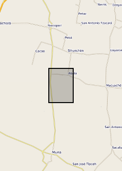
Surface waters and shallow groundwater samples were collected by completely filling 30 mL polyethylene bottles, which were then sealed with electrical tape to minimise the risk of evaporative loss. Rainwater samples were integrated samples of total monthly rainfall collected in a specially-adapted rainfall collector following IAEA protocols (IAEA http://www-naweb.iaea.org/napc/ih/documents/userupdate/sampling.pdf [accessed 22 June 2012). Mexico, State of Yucatan. Yaal Chac (lake) (lake centre is Lat: 20.595274 degrees; Long: -89.711301 degrees), Abala Well (Lat: 20.649044 degrees; Long: -89.679814 degrees) and Xanil ha Cave (Lat: 20.650809 degrees; Long: -89.697426 degrees) Rainwater sampler was located adjacent to the lake. Refer to accompanying map for the precise location of the sampling sites.